
Hien Luong Bridge and Ben Hai River
Introduction
Hien Luong Bridge and Ben Hai River are famous clusters of relics, and the 17th parallel divides the two regions of Vietnam. These are two “historical witnesses” who saw the entire history of the North and South separation during the Vietnam War. During the war, this played an essential role in the wars against France and the United States.
Hien Luong Bridge and Ben Hai River have witnessed many separations because of war. This is a famous place, and many people come here to visit. In the past, there have been many wars before and after the signing of the armistice with France. There used to be many war soldiers who fought and died to entrench these two places.
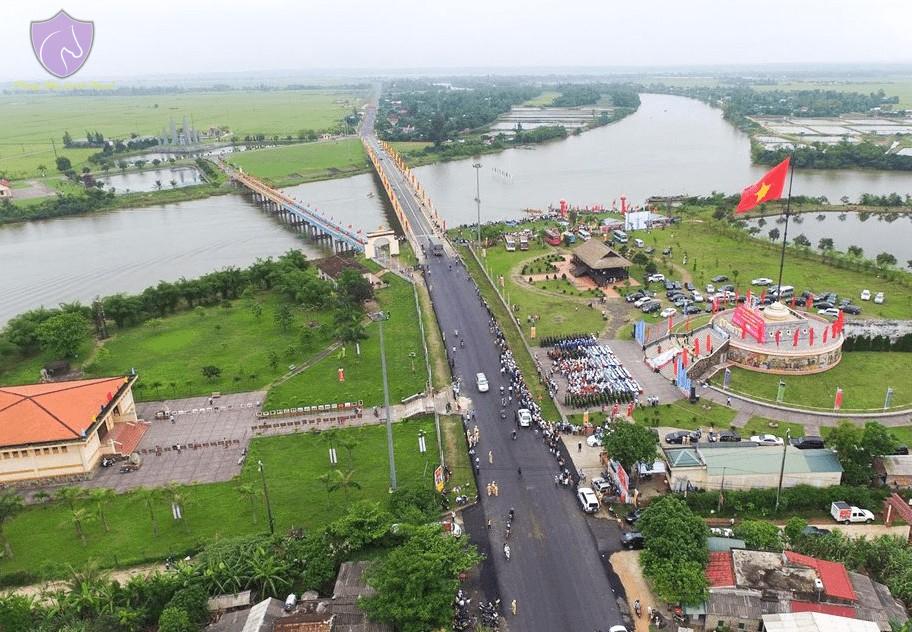
Have modern Hien Luong bridge today, few people know that it has had to go through many times of construction and repair. During the wars against the US and France, this was always a critical road to serve military purposes and bring victory. Now, let’s explore the historical stories of the Hien Luong Bridge and the Ben Hai River with Phong Nha Locals.
- You may be interested in our Hoi An to Phong Nha private car, Hoi An to Dong Hoi Private Car, and Dong Hoi to Da Nang private car.
History of Hien Luong Bridge And Ben Hai River
Ben Hai River
The Ben Hai River originates from Dong Chan mountain in the Truong Son range and flows along the 17th parallel, flows from the west to the east, and runs into the sea at Cua Tung. Ben Hai is a place upstream of the river, so the name Ben Hai river is taken from this place. Ben Hai River flows about 20km from the sea, then joins with Sa Lung River on the left, and the two rivers combine to form one flow into the East Sea. On the way, it flows through a Minh Luong village, and people use the name Minh Luong to call the river.

During the Minh Mang Nguyen Dynasty, village and river names have to change to Hien Luong. Then, when there was a bridge across the river near the confluence of the Sa Lung and Ben Hai rivers, it was also named the Hien Luong bridge.
The reason why this Ben Hai river is famous is that it was the place that divided the North and South during the Vietnam War. The Republic of Vietnam takes control of the South, and the Democratic Republic of Vietnam takes control of the Nouth. Geographically, the river deviated to the South of the 17th parallel; according to the Geneva accords, this was a temporary demilitarized line in 1954.
Hien Luong Bridge
From 1928 to 1945
Hien Luong Bridge crossed the Ben Hai River at Hien Luong village, Hien Thanh commune, Vinh Linh district, Quang Tri province, Vietnam. This is a bridge of historical value to the Vietnamese people, as it is the point separating the two regions of Vietnam. This is a place that many people visit during the Vietnam DMZ Tour, especially veterans both in and outbound.

Before being built and repaired into a modern bridge like today, before 1928, there was no bridge here. The only way to cross the Ben Hai River is to use a ferry. The first Hien Luong Bridge was built in 1928 by the Vinh Linh government, calling on people to build together. They use wood and iron piles to build the bridge, 2m wide; the tonnage is only enough for pedestrians.
In 1931, the Indochinese Federation repaired the bridge, but motorbikes who wanted to cross the river still had to go by ferry. In 1943 the bridge was upgraded again; at this time, small motor vehicles could cross. But it has not been used for military purposes yet.
From 1950 to 1967
In 1950, the French rebuilt the Hien Luong bridge with concrete, 162m long, 3.6m wide, and 10 tons of tonnage for use in military purposes. This bridge existed for two years before being demolished by Viet Minh with bombs. The purpose of this was to block the path of the French army. But in May 1952, France rebuilt a new bridge to continue serving the Vietnam War.

The new bridge consists of 7 spans, 178m long, reinforced concrete pillars, steel girders, pine wood paving, 4m wide, 1.2m high barriers on both sides, maximum bridge load is 18 tons. This new bridge worked for 15 years, but in 1967, the US bombed and collapsed this bridge.
From 1972 to 1974
From 1972 to 1974, to serve the Southern battlefield, The Liberation Army of South Vietnam built a pontoon bridge 20 meters west of the old bridge. In 1974, the government of the Democratic Republic of Vietnam rebuilt with reinforced concrete 186m long, 9m wide, with a pedestrian corridor 1.2m wide. This bridge opened the route to the South to support the war and, since then, successfully reunified Vietnam.

After the Vietnam War ended
Established in 1996, the Ministry of Transport built a new bridge 230m long and 11.5m wide after the war ended. The old bridge was severely degraded during the war and was no longer usable. In 2001, the government restored the iron bridge 1952 to its original form according to the design of the old bridge in 1967.

History of the division of Vietnam DMZ
In 1954, after losing the decisive strategic battle of Dien Bien Phu, France agreed to return independence to Vietnam under the Geneva Agreement. Ben Hai River and Hien Luong Bridge at the 17th parallel become the boundary dividing Vietnam into two regions.
The Army of the Democratic Republic of Vietnam withdrew to the North, and the army of the French Union withdrew to the South. According to the original plan, from 1954 to 1956, a general election would be held to unify the country completely.

But in 1956, Ngo Dinh Diem, president of the Republic of Vietnam, refused to participate in the general election, so the Ben Hai River continued to divide the country. Today, a statue on the Ben Hai River’s southern bank expresses the Vietnamese people’s desire to unify the country. The statue bears the image of a woman looking north in memory of her husband and relatives when unable to see each other.

It was not until 1976, when Vietnam won the victory over the US and forced the US to sign the Paris Agreement, that Vietnam officially reunified. This is also when the 17th parallel is no longer the place separating the two regions of Vietnam.
Wars in the Vietnamese Demilitarized Zone
Hien Luong Bridge and Ben Hai River are demilitarized zones, so wars are not allowed here or other forms of war. Although not using the method of armed war, but here also broke out the war between the two factions.
The war of paint
In the middle of the Hien Luong Bridge, a white horizontal line about 1cm thick divides the bridge into North and South parts. When the Republic of Vietnam actively paints the southern half of the bridge blue, the Democratic Republic of Vietnam immediately paints the other half blue. After the Republic of Vietnam turned brown, the Democratic Republic of Vietnam also repainted it brown.

For many years, Hien Luong Bridge has always changed color. Every time the Republic of Vietnam changes its paint color to make a difference, the Democratic Republic of Vietnam does the same thing. Finally, in 1975, the bridge shared a unified blue color.
The war of sound
The years 1954-1964 were when there was no gunfire at the Hien Luong bridge and Ben Hai river; the voice battles that took place here were very intense. The Democratic Republic of Vietnam built a speaker system distributed into 5 clusters in a length of 1,500m on the North bank; each cluster consists of 24 speakers with a capacity of 25W. But this speaker system is not enough to compare with the Republic of Vietnam when sponsored by West Germany and Australia.

After receiving aid from both sides, the Democratic Republic of Vietnam has Russia, and the Republic of Vietnam has the US. Hence, war is easy to break out continuously. Every day, the radio broadcast lasts 14-15 hours, sometimes at 1-2 am, open at full capacity so people on both sides can hear it.
Flag War
According to the Geneva Accords provisions, all border police stations must fly their flags daily. This was originally normal, but it became unusual when both wanted to stand out. In 1954 - 1956, the Democratic Republic of Vietnam government made a 12m high casuarina flagpole to hang a flag.

On the southern bank, France planted the French flag on the roof of Xuan Hoa blockhouse on the south bank, 15m high. At the request of the people, the flag of the Democratic Republic of Vietnam must be higher than the Republic of Vietnam.

Soldiers of the Democratic Republic of Vietnam government went into the forest to find a wooden tree 18m high, 3m higher than the French flagpole, and hang a flag 24m wide. Right after that, Ngo Dinh Diem erected a 30m high reinforced cement flagpole on the south bank. On the top hangs a large flag of the Republic of Vietnam, with a fluorescent lighting system. In July 1957, Vietnam Machinery Installation Corporation made a 34.5m high steel pipe flagpole to hang the 108m wide flag.
This war continued after that until the war ended. From May 19, 1956, to October 28, 1967, the North Vietnamese security soldiers flew 267 large flags.
That is the information about the cluster of landmarks, Hien Luong Bridge and Ben Hai River, which have become a part of Vietnam’s history. We, Phong Nha Locals, hope the above information will be useful to you. You can click Vinh Moc Tunnels In Vietnam for more details if you need more information about Vinh Moc Tunnels in Vietnam. Or, if you want to know about tourist attractions in Vietnam DMZ, you can view more at Khe Sanh Combat Base-Vietnam DMZ.
Link nội dung: https://melodious.edu.vn/hai-nha-a111671.html